Watersheds are landscape drainage basins defined by topographic highs, called “divides” that separate one watershed from another. Surface and groundwater flow from higher to lower elevations and into streams. The watershed concept connects the land and water to the people who live with it. Land surface cover type and use affect the quality and quantity of water within a watershed and, as USGS hydrologist Luna Leopold once said, “the health of our waters is the clearest measure of how we live on the land.”
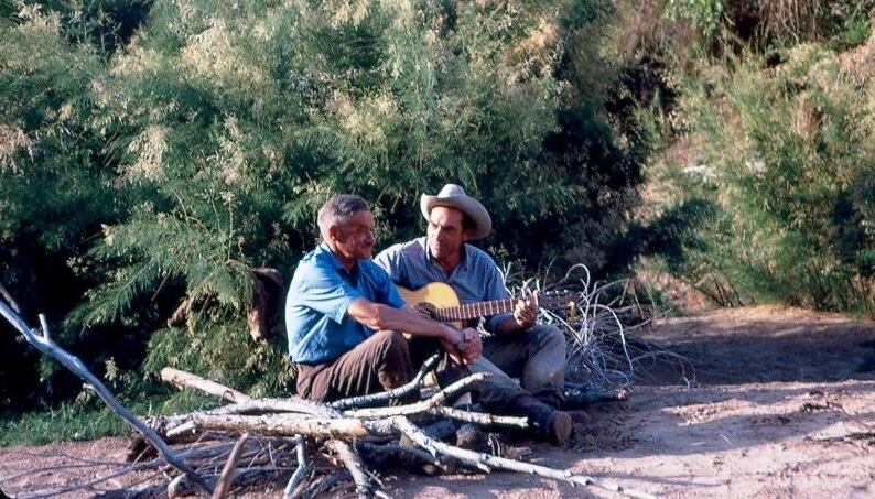
Luna Leopold (hat and six-string) with physicist Ralph Alger Bagnold c. 1970 (source: USGS).
Knowing the factors contributing to the frequency and severity of floods requires collection and analysis of watershed data. In the 1971 USGS publication Estimating Magnitude and Frequency of Floods in Wisconsin, hydrologist Duane Conger developed a flood model based on the effects of different watershed characteristics. Those characteristics included in the model are:
Drainage Area
Main Channel Slope
Lake and Marsh area (%)
Main Channel Length
Forest Cover Area (%)
Mean Annual Precipitation
Mean Minimum January Temperature
Mean Annual Snowfall
Soil Index (infiltration capacity similar to Hydrologic Soil Group)
Mean Frost Depth on February 28
Mean Snow Depth on February 28
Precipitation Intensity Index (2-year 24 hour rainfall)
Areal Factors differences between observed and computed statistical values and related to soils, geology and physiography.
In conclusion, Conger wrote (emphasis added), “of the several basin characteristics used in this study, only drainage area, main channel slope, lake and marsh area, and areal factors were found to be statistically significant at the 99 percent effectiveness level for all flood frequencies.”
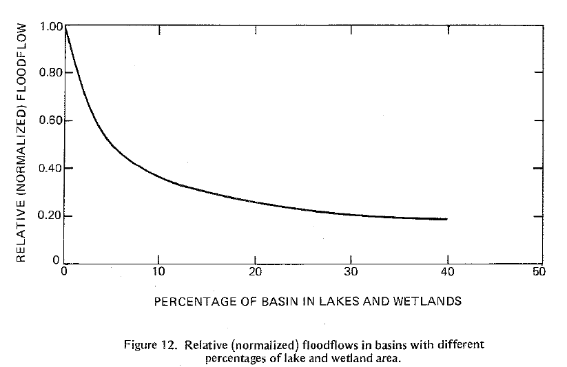
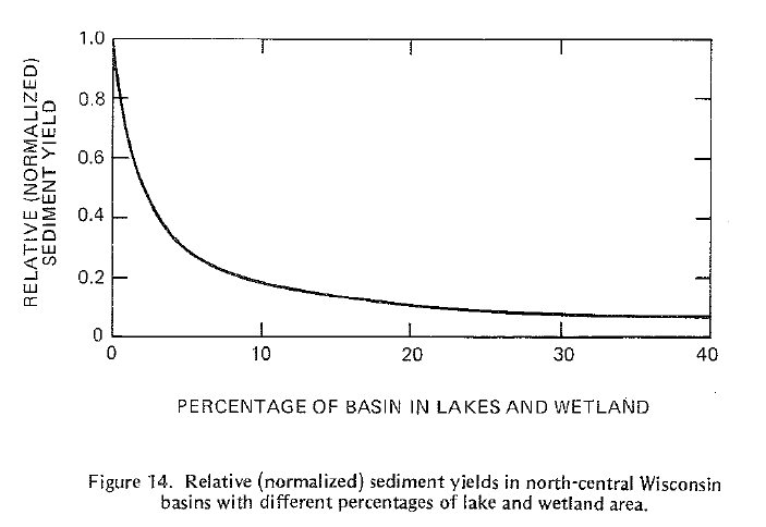
Building on Conger’s work, USGS hydrologist Richard P. Novitzki published Hydrology of Wisconsin Wetlands (1982) and related watershed wetland and lake area to flood flows and sediment yields. Graphed in Figure 12, and Figure 14 (Novitski, 1982), data show a substantial reduction in flood flows and sediment load, respectively, when watershed lake and wetland areas approach 10 percent.
At this point, one might wonder how much of their own watershed is wetland. Beginning in the 1970s the U.S. Fish and Wildlife Service National Wetland Inventory has been mapping the nation’s wetlands based on aerial photos, satellite imagery, soil and topographic maps and field verification. This information is publicly available and widely used for research and planning purposes.
Sometimes, due to the way our layers of government are organized, including the role of county extension agencies, wetland data are reported by county as shown in Appendix A, Status and Trends of Michigan’s Wetlands: Pre-European Settlement to 2005. However, the Michigan Department of Environmental Quality (MDEQ) in 2017 published biological reports on specific watersheds.
The Pere Marquette River is listed as a “blue ribbon” trout stream in West Michigan with extensive woodland and wetland habitat. While on a canoe trip, I drank straight from the river with no ill effects, although I don’t recommend others do so (giardia, etc.), unless that’s all that’s available. It’s a beautiful river with a lot of wetland and forest in much of its watershed. The MDEQ biosurvey report found about 14.5 percent wetland area for the entire watershed. Looking at 19 subwatersheds with tributaries feeding into the main stem, wetland areas ranged from 3 percent to 31 percent coverage.
By contrast, a 202o report on the Detroit area River Rouge by the Michigan Department of Energy Great Lakes and Environment (EGLE) listed wetland areas for the Rouge and nearby watersheds as follows: River Rouge Watershed 2.63%,
- River Rouge Watershed 2.63%
- River Raisin Watershed 8.2%
- Clinton River Watershed 7.84%
- Huron River Watershed 13.03
Understanding that other landuse area factors such as urban impervious surface, cultivated agriculture, forested, and other factors need to be considered when planning for a healthy watershed, the “10 Percent Solution” may be a feasible target to reap the benefits of wetlands functions.
The economic benefits of wetlands may not be easily calculated but the rising costs of flood insurance, damages and mitigation are real. The rising cost of treating drinking water to remove sediment, bacteria and chemicals is real.
Sixty-two percent of Great Lakes Watershed wetlands have been lost, and despite laws and regulations intended to protect wetlands, the losses continue. Restoring some of them can help us out.


Leave a comment